
Disclaimer:
The authors are solely responsible for the content of this report. Material included herein does not represent the opinion of the European Community, and the European Community is not responsible for any use that might be made of it.
Back to overview reports
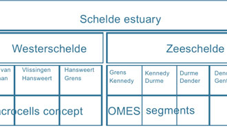
Level 1 is the entire ecosystem, the Schelde estuary as a whole. The most upward boundary is a sluice complex near the city of Gent where the tidal action is stopped. At the seaward end, the mouth is usually defined as the line connecting the cities of Breskens and Vlissingen. In front of the so defined mouth there is however an alluvial deposition zone, called ‘Vlakte van de Raan’, stretching out in the coastal water, and which is often considered as the estuarine mouth area.
Level 2 consists of two zones, the Dutch part, called Westerschelde, and the Belgian or Flemish part, called Zeeschelde. The zonation criterium of level two is thus merely the national border line.
Level 3 is a zonation based on a mixture of administrative and physical criteria (mainly salinity and residence time). In the Zeeschelde, the Upper and Lower Zeeschelde are managed by different government bodies.
Level 4 is a modeling based zonation consisting of macrocells concept within the OMES project. They have been used in monitoring programs, scientific studies, descriptions etc.
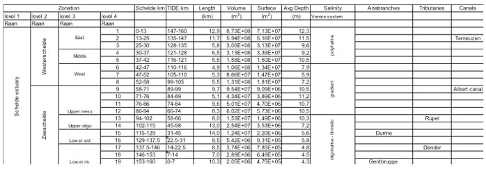
The basic characteristics of the Schelde zones at level 4 are (at an average tidal level) a salinity typology of the present condition (Venice system), the presence of morphological entities such as tributaries, anabranches and canals (Table 1). For the calculation of volume and surface area, an average tide was used. The freshwater compartments 17-20 have a short residence time less than 5 days. The freshwater compartments 15-16 have a long residence time more than 5 days.
Back to top
Zonation of the TIDE estuaries
Table of content
Authors:
by Lindsay Geerts, Kirsten Wolfstein, Sander Jacobs, Stefan van Damme & Wouter Vandenbruwaene
by Lindsay Geerts, Kirsten Wolfstein, Sander Jacobs, Stefan van Damme & Wouter Vandenbruwaene
3a. 2a. Zonation per estuary - Schelde
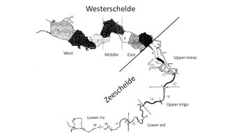
The zonation of the Schelde estuary consists of the following levels (see also figs. 1 and 2), in which level 1 and 2 are based on administrative criteria, whereas level 3 is a combination of administrative borders, salinity and residence time criteria. Level 4 consists of model compartments, giving some arbitrary small scale divisions.Level 1 is the entire ecosystem, the Schelde estuary as a whole. The most upward boundary is a sluice complex near the city of Gent where the tidal action is stopped. At the seaward end, the mouth is usually defined as the line connecting the cities of Breskens and Vlissingen. In front of the so defined mouth there is however an alluvial deposition zone, called ‘Vlakte van de Raan’, stretching out in the coastal water, and which is often considered as the estuarine mouth area.
Level 2 consists of two zones, the Dutch part, called Westerschelde, and the Belgian or Flemish part, called Zeeschelde. The zonation criterium of level two is thus merely the national border line.
Level 3 is a zonation based on a mixture of administrative and physical criteria (mainly salinity and residence time). In the Zeeschelde, the Upper and Lower Zeeschelde are managed by different government bodies.
Level 4 is a modeling based zonation consisting of macrocells concept within the OMES project. They have been used in monitoring programs, scientific studies, descriptions etc.
The basic characteristics of the Schelde zones at level 4 are (at an average tidal level) a salinity typology of the present condition (Venice system), the presence of morphological entities such as tributaries, anabranches and canals (Table 1). For the calculation of volume and surface area, an average tide was used. The freshwater compartments 17-20 have a short residence time less than 5 days. The freshwater compartments 15-16 have a long residence time more than 5 days.
Important to know
Reports / Measures / Tools
| Tool: | Zonation of the TIDE estuaries (Recommendation) |
|---|


