
Disclaimer:
The authors are solely responsible for the content of this report. Material included herein does not represent the opinion of the European Community, and the European Community is not responsible for any use that might be made of it.
Back to overview reports
Back to top
How can public acceptance for management actions be increased?
How can the Ecosystem Services Approach be used to support management decisions?
How can we assure accessibility to an inland estuarine port without affecting the habitats and safety against flooding?
How can we prevent excessive degradation or loss of tidal marshes?
How does habitat management affect the supply of ecosystem services?
What are the key areas of conflicts or synergies in TIDE estuaries?
What are the restoration opportunities for side branch systems and river banks (e.g. left side branch Weser)?
What factors determine the distribution of suspended sediments in an estuary?
What measures are successful for the dissipation of tidal energy?
What monitoring is required to support and assess management decisions?
What parameters should be used to define and evaluate measure targets?
What tool is available to help manage multiple users of a resource in an integrated way (i.e. achieving more holistic management)?
Which aspects do I have to take into account in order to make a measure a success?
Which measures are suitable to achieve specific ecological targets?
Which measures are suitable to achieve specific morphological and hydrological targets?
Which measures are suitable to identify, protect or develop valuable submerged habitats e.g. mussel beds and Sabellaria reefs?
Which measures are suitable to improve the physical characteristics and chemical water quality?
Which measures are suitable to provide ecosystem services and benefits?
Which synergistic effects and conflicts can be expected by planning and implementing a certain measure?
“Working with nature”: What are the opportunities for sediment management in estuaries?
Management measures analysis and comparison
Table of content
- 1. Aim of the study
- 2. Work organisation
- 2a. Transnational Working Group Measures (TWG Measures)
- 2b. Regional Working Groups
- 3. Working steps and methods
- 3a. Measure collection and compilation of basic information
- 3b. Analysis approach development
- 3c. Consistency check of analysis results
- 3d. Develop concepts for cross estuary comparison of measures
- 3e. Deduce recommendations for estuary managers
- 4. Pilot projects
- 5. Results of measure collection and analysis
- 5a. Measure collection and basic info compilation
- 5b. Measure analysis
- 6. Specific issues of cross estuary comparison of measures
- 6a. Managed re-alignment measures (APA)
- 6b. Measures influencing sedimentation processes (HPA)
- 7. Summary and conclusions
- 7a. Procedure
- 7b. Results
- 8. Recommendations
- 9. References
- 10. Annex
- 10a. Composition of Regional Working Groups identifying main pressures and resulting deficits for the estuary zone using Environmenta
- 10b. Templates for evaluation of measures in terms of WFD aims: Identification of pressures and explanation of resulting deficits for
- 10c. Templates for evaluation of measures in terms of Natura 2000 aims: Conservation objectives for relevant operational areas based
- 10d. List of collected measure examples from Weser, Elbe, Humber and Scheldt with indication of development targets
- 10e. Assignment of collected measure examples from Weser, Elbe, Humber and Scheldt to measure categories
- 10f. Overview maps on measure titles and locations
- 10g. Assignment of collected measure examples from Weser, Elbe, Humber and Scheldt to measure types
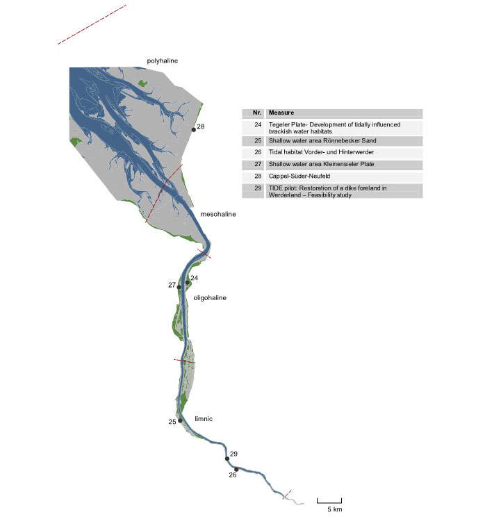
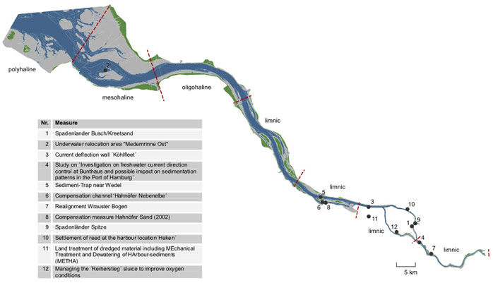
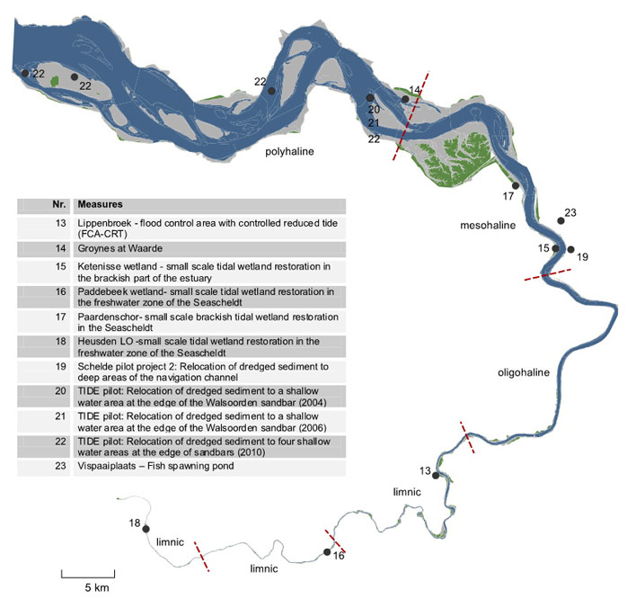
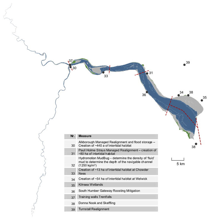
10f. Overview maps on measure titles and locations
10e. Assignment of collected measure examples from Weser, Elbe, Humber and Scheldt to measure categories 10g. Assignment of collected measure examples from Weser, Elbe, Humber and Scheldt to measure types
Important to know
Reports / Measures / Tools
| Report: | Management measures analysis and comparison |
|---|
Management issues
How and by which management measures can tidal amplification be reduced?How can public acceptance for management actions be increased?
How can the Ecosystem Services Approach be used to support management decisions?
How can we assure accessibility to an inland estuarine port without affecting the habitats and safety against flooding?
How can we prevent excessive degradation or loss of tidal marshes?
How does habitat management affect the supply of ecosystem services?
What are the key areas of conflicts or synergies in TIDE estuaries?
What are the restoration opportunities for side branch systems and river banks (e.g. left side branch Weser)?
What factors determine the distribution of suspended sediments in an estuary?
What measures are successful for the dissipation of tidal energy?
What monitoring is required to support and assess management decisions?
What parameters should be used to define and evaluate measure targets?
What tool is available to help manage multiple users of a resource in an integrated way (i.e. achieving more holistic management)?
Which aspects do I have to take into account in order to make a measure a success?
Which measures are suitable to achieve specific ecological targets?
Which measures are suitable to achieve specific morphological and hydrological targets?
Which measures are suitable to identify, protect or develop valuable submerged habitats e.g. mussel beds and Sabellaria reefs?
Which measures are suitable to improve the physical characteristics and chemical water quality?
Which measures are suitable to provide ecosystem services and benefits?
Which synergistic effects and conflicts can be expected by planning and implementing a certain measure?
“Working with nature”: What are the opportunities for sediment management in estuaries?


